FIRST DISCOVERIES
I had read Henry Lincoln’s book ‘The Holy Place’* which suggested that ancient (and perhaps not so ancient) sites were often ‘arranged’ by their builders to form some regular pattern in the landscape. One day I found myself idly looking at an Ordnance Survey map of the Vale of Glamorgan and, knowing it to have been inhabited since the very earliest times, I wondered whether it might be worth exploring local alignments and positionings of sites in the landscape.
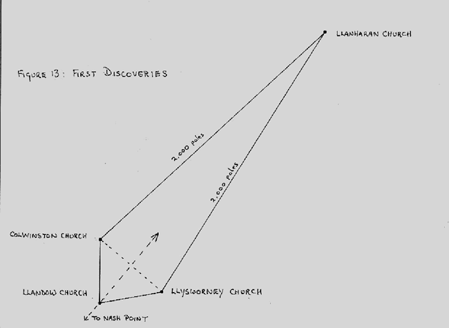
At the time we lived in the little village of Colwinston, one of a trio of local villages, the other two being Llandow and Llysworney. All three villages have fine mediaeval churches that, almost certainly, are built on ancient sites.
When I looked at the map I saw something strange. This was that Colwinston and Llysworney churches were both located exactly the same distance from Llandow church. This distance was about 2.1 kms. This distance itself wasn’t remarkable. But by drawing a triangle with the churches at the corners I observed something else.
Fig 13 - The Arrangement of Colwinston, Llandow and Llysworney Churches
The triangle formed by the churches was like a bow being pulled with Colwinston and Llysworney churches representing the ends of the bow and Llandow the middle of the bowstring. What would happen if I ‘fitted’ an arrow to the bow, I wondered?
This done it was clear that the arrow pointed directly at the site of Llanharan church. I now measured the distances between Colwinston and Llanharan and between Llysworney and Llanharan. The structure I had created on the map was symmetrical so both distances were the same. I measured those distances: they were each 10 kilometres. That distance is approximately 2,000 poles. (Click on the link below for more information on the Pole as an ancient unit of measure).
Here then we have them four churches in a regular geometric structure whose greatest length (Llandow to Llysworney) is some 2300 poles (11.5 kilometres). Moreover, the long axis of this structure aligns to Nash Point, a prominent landmark on the coast of the Vale of Glamorgan.
I found it impossible to conceive how such an arrangement of sites could have happened by chance. There is first the regularity of the structure, then the precise distances of the two long sides (2,000 poles) and lastly the alignment to Nash Point. While any one of these might have theoretically occurred by chance, the probability of all doing so is infinitesimal.
So here I had real evidence that whoever had laid out the positions of these sites had the capacity to measure over extensive distances and position sites with great accuracy. This was my first ‘discovery’ of landscape alignments in the Vale of Glamorgan.
But who laid out these sites? And why? Even more important perhaps is the question of how the ancient people were able to accomplish such sophisticated alignments.
* Henry Lincoln, The Holy Place, Jonathan Cape, London, 1991
BACK:Home Page and Index
MORE DETAIL:
The Pole - an Ancient Unit of Measure